
Barot Adventure with Trout Fishing - Barot-Lohardi-Sari Pass - Kullu Valley Trek Package- Chhota Bhangal Trek8 DaysPackage Code: HTPC000292
from
On request

Satisfaction Guarantee
Cheapest Flights and Hotels with Excellent holiday travel packages & Tour packages.
Need Holiday Help?
We would be more than happy to help you. Our team advisor are 24/7 at your service to help you.
+91-8350824253(9AM-6PM)+91-9819007620(24X7)
+91-1975223185(24X7)
holidaytravel.co@gmail.com
Related Destinations
Barot Adventure with Trout Fishing - Barot-Lohardi-Sari Pass - Kullu Valley Trek Package- Chhota Bhangal Trek
- Trek Name : Barot Adventure Trek with Trout Fishing
- Trek Key Attractions :- Barot Village Fishing, Wild Trout Fishing, Lohardi Village Life, Andrali Malhan Village Life, Astonishing Views from Sari Pass, Glaciar walk, Steep Descent to Kullu Valley, Teyun Village Life
- Maximum Height: 3760 Mtrs.
- Requirement: Experience in trekking essential
- Period: May- June, September- October
- Duration: 8 days
Related Tags
Barot Adventure with Trout Fishing - Barot-Lohardi-Sari Pass - Kullu Valley Trek Package- Chhota Bhangal Trek, Best Treks in June till October | Chhota Bhangal Trek Package| 12000 feet Trekking| Trek to Kullu from Barot | Sari Pass trek review| Sari pass trek costs| Sari pass itinerary|Trek from Lahordi Village| Andrali Malhan Dahansar lake Sari Pass Teun village Trek| Dharamsala over sari Pass Kullu|Fishing in Uhl River
Barot Adventure - Sari Pass Gogle Earth Trekking Map
.jpg)
Sari Pass Trek Map
Barot Adventure & Sari Pass Trekking Map In Order of destinations with Coordinates & Altitudes
- Billing Paragliding GPS Coordinates & Google Earth Map
- Alitude - 7900 feet
- Coordinates - 32° 3'28.78"N, 76°44'41.55"E
- Kothi Koher
- Altitude - 7800 feet
- Coordinates - 32° 4'57.14"N, 76°47'50.24"E
- Barot
- Altitude - 6000 feet
- Coordinates - 32° 2'28.76"N, 76°50'24.81"E
- Lohardi Village
- Altitude - 6641 feet
- Coordinates - 32° 4'34.51"N, 76°51'28.93"E
- Andrali Malhan Village
- Altitude - 8000 feet
- Coordinates - 32° 4'28.20"N, 76°52'31.44"E
- Sari pass Top
- Altitude - 12000 feet
- Coordinates :- 32° 3'9.77"N, 76°56'14.12"E
- Dehansar lake
- Altitude - 11200 feet
- Coordinates - 32° 6'49.48"N, 76°54'22.95"E
- Tayun Village
- 32° 2'44.94"N, 76°58'55.61"E
- Samalang Village
- 32° 3'8.55"N, 76°59'37.78"E
Barot Adventure & Sari Pass Trek in Chhota Bhangal To Kullu Valley and Manali- Package Itinarary
Day-1 Arrival Mcleodganj (2000 mts.)
Reach Mcleodganj and acclimatization walk around Mcleodganj and visit to the monastries.
Day-2 Mcleodganj to Bir , by jeep – 4 hours,
Bir is emerging as a popular tourists destination now because of Buddhist monasteries . There are good Tibetan settlements, and foreigners are attracted to study the Tibetan Culture. There are beautiful tea garden and tourists enjoy the Kangra tea flavour.
Day-3 Bir- Billing(2800 mts.)
Billing is located on a ridge without any vegetation. There is a forest bungalow which serves as a resting place for trekkers and tourists. Billing is famous for conducting hang- gliding, Para-gliding competition. it gives a panoramic view of the valley below. From this place one can choose to go to Barabhangal after aloosing Thamsar Pass.
Day-4 Billing- Kothi Kohar village- 14 kms.
Setting Up Tent Camp in Billing
Reach Billing Top by the evening and you will see why the place is a heaven for paragliders. Billing is Slightly higher than Triund but has same soft green meadow at one end falling into the deep gorge providing wonderful take-off point for gliders. You can see the lights of Baijnath in night. You can set up the camp in front of a little outhouse, basically a wooden structure. Water Stream is also near by to fetch clean water. It becomes very windy on the top so be inside the tent in the warmth of the tent and sleeping bags.
Unlike Triund, Billing is a Quite place, and a great unpolluted place to be.Similar to Triund it is a great meadow stretching to the main dhauladhars.
Trek to Khalhail ( 7000 ft)
From Billing, you start the trek to Khalhail, enroute you will see a Tea shop , it is the only tea shop enroute this trail to have hot tea, and Maggi & lunch, You can have rest here and proceed on the trail to Baragram and Kothi Kohr. There is a sharp descend onto cultivated terrain surrounding the villages Mehot, Khalhail,
Khalhail is at about the same elevation as Mayot is A tiny village, with one ‘general purpose’ shop and a tiny school, it directly overlooks the winding river and proximity to a craggy shoulder of the Pir Panjal.In Khalhai, you can enjoy pakoras and thadda (a local wheat-based clear alcoholic drink).
The road from Barot to Lohardi (6 kilometres) is motorable, but you can still walk to reach this place through great forests.
Kothoi Kohar falls in the backward area of Chhota Bhangal enroute one can see many species of herbal plants. The catchment area of the nearby village i.e. Rubling river and other tributaries from the Uhi river which later merges at barot in to Lama Dugh river which descends from Lohardi.
Day-5 Kothi Kohar- Lohardi- 19 kms
Busable route and frequently of buses is limited to 3-4 buses a day. Lohardi is a lovely village on the left side of the Lama Dugh river. This area is becoming more and more popular amongst foreign tourists for its quietness and exquisite beauty. Lohardi is now coming up with a small town. At a distance of 4 kms. Village Swar is perched on a hillside and has terraced field of potato cultivation and apple orchards. This region is visited by botanists for collection of rare species of medicinal plants of their interest.
Day-6 Lohardi- Andarli Malhan - lahesh Cave(3200 mts.)- 14 kms.
At Lohardi (6,710 ft), the road ends again, and a narrow trail winds up into the further reaches of the valley. In Lohardi, basically you stop for stockpiling and rejuvnating the energy. There is a dhaba in Lohardi offering rice, two kinds of dal, yogurt-based kari.
From Lohardi, Trail to Sari Pass starts, It is a short way from Lohardi to Andarli Malhan, but all uphill,
.jpg)
LaheshCave_Camp_enroute_sariPass (640x480) - Coutsey exteneded to team for sharing
Andarli Malhan, approximately 6,900 ft
Andarli Malhan, It is the last village and enjoys a ravishingly beautiful setting. From its highest slopes, the Pir Panjal whites are clearly visible, and from its loYoust, the winding Barot-Uhl. The road from Khalhail to Barot is all a pleasant gradual downhill walk. You reach barot and enjoy the roar of uhl river and yes famous trout fish. Andarli is a inner Himachali village with meticulous woodwork and architecture,From the highest point in the village, You enjoy the the full curve of the green cirque of mountains,adjoining fields and terraces.Andarli Malhan faces Youst, with the first sun touches the fringes of trees in the spur of mountain immediately facing the village.
This trek is moderate one and is visited by the local people and trekkers to cross Sari Pass which paves the way to Kullu valley. Lahesh cave can accommodate 3-4 persons. You can also pitch your tent
Day-7 Lahesh Cave- Sari Pass -3 kms.
Sari Pass Crossing In May from Lahesh
.jpg)
SariPass_VisibleFromLahesh (640x480) - Courtsey extended to team for sharing
Winter is always severe in these parts of Himachal, In April/May, The place is completely snowbound and not a single shepherd crosses in from the Kullu side or Barot side. If you Youar snow boots, its good and also having snow equipment ( Ice axe, rope etc) is fine, But do not worry, if you do not have it, You can do it the Gaddi way, Take staffs made out of stout wood, with one end pointed to simulate the spike of the axe. The extra-long shafts of the staffs are a big help.
Secrets of Successful Sari Pass Trek
Successful Sari Pass trek depend on the sun and consolidation of the snow, As compared with Indrahar, camping grounds in Sari Pass are well below the pass on both sides. The pass will therefore takes long time to reach, and a while to get off. So, On Sari Pass, Be prepared for a long day.
So start as early as possible by 4 AM, Then you can also cover glacial lake called Dainasar a bit north of Sari Pass. Could You veer by the lake on the way down from the pass.
Trek to Sari Pass is like a dream of a walk. Going into deeper, higher, mazy reaches of the valley, enroute you will find wood gatherers and fieldworkers around Andarli, but an hour or so onwards trekking, the habitation turns virgin with The trail gets overgrown with whitish grass,As you go higher, it became necessary to move from shoulder to shoulder of mountain so to keep due east in the direction of Sari. Also you need to cross the river and streams at multiple places, You may end up doing 4-5 crossings, be careful not to get drentched here. Enroute you will find wild wallnuts to have energy level boosted up.
.jpg)
SariPass_WalkOnTop (640x480) - Courtsey Extended to team
Some where here, you take your time selecting a patch to pitch up a tent and camp
Sari Pass Glaciar Dream Walk
Finally you will be approaching Sari Pass, You approach a wide stretch of glacier which never melts even in high summer or rains, finally connects to Sari Pass. The Glaciar walk is approx 1000 feet with steep ascent and narrow walks, to your right, a fall into a few hundred feet sheltering another tongue of glacier. The thick lushness of the valley is behind you, The ascent gets tough and glaciar only growing in size as you go up
Climbing the ridge is a hard work because of its steepness, You can enjoy the look back at the valley and with every single time, the view changes. Enroute to the pass, you will encounter many rhododendron shrubs, The Trick hetre is to walk through the Shrubs, no to get round from shrubs. Shrubs are always firmly footed, so there is no chance to falling down into a creavas, so always walk through the bush.
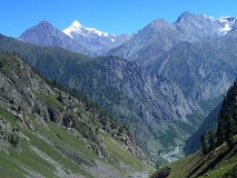
While on the Ridge, To the Youst, in Kangra, You can see the Dhauladhar stood in layers upon layers threaded with white. To the east stood the distant peaks of the Kullu and Parvati Valleys and to the north, the range Yount further into the higher Pir Panjal – in the direction, You can see the Kaliheni Pass on the Bara Banghal, whcih still not opens in May.
Offering to the Sari Pass
While you are on the top, You must make first little offering to the Pass of what ever you can, this tradition is folloYoud by Gaddis and shephards, When you will reach villages in Kullu a couple of days later, one of the first questions from the shepherds will be whether you had made an offering while at the Sari Pass. The first crossers every year customarily offer a sheep.
About Sari Pass
Sari Pass is extremely modest at only 12,500 feet – quite a bit loYour even than Indrahar, which is itself a mini sort of pass. But what a view this little pass commands – particularly on the Kullu side – and what a sense of connection of the visible and invisible world is yours on top of it. You will be able to see flows of Lohardi and Barot, also both Uhl and Sarbari turning round to become the Beas that would ultimately also take in the Parvati, Also the Manimahesh range in the high Youst, View of beautiful slightly lonely bit of mountain a bit to the south in the Kullu valley.
Day 8 - Descent from Sari Pass to Tyun Village
Tenu village is the last village of Kullu valley. People are utmost orthodoxical and do not compromise with their customs and traditions. One can have good look of the Kullu valley all along the route
From the Sari Top, you can also do Dehansar Lake Excursion, and descending in the direction of the village of Tyun, You can attempt a descent from a bit further north in the range, so that you can walk through one of the big glaciar which descents down. Route towards kullu is mostly through glaciers and snow-tongues had recently receded from. Leaving them terribly unpacked, slushy, and treacherously slippery.
Once on the decent, there is no stopping for up to an hour. For to stop meant having to check your momentum and find a rest for your feet, The glacier feed directly into one of the Sarbari flows,to prevent potential slips and slides by arresting with the staff, and to keep walking though there was never an end in sight to the massive white fall.
About three hours into this knee-crunching and shoulder-shattering exercise, It is time to set up camp, It is couple of thousand feet from Sari Top, but still quite high up. More importantly, the snows had nowhere relented to the extent of freeing up grassy patches.
Finally you came to a big turn of the glacier, Readying camp here was, um, an experience. The inclined little shelf did have room for our tiny tent, but in order to pitch it, You had to spend a solid hour uprooting thorn bushes and cutting down jutting branches and roots of rhododendron shrubs, and then using big flat stones to cut out blocks of earth to lay out in a platform for the tent. The ground sloped considerably, and the skies portended rain.
You simply had to make certain that the platform for the tent was high and secure and solid enough that You wouldn’t be washed off on to the glacier from the already Yout and slippery earth, tent and all. Backbreaking work for tired people, but I know now that it was the correct decision to have made. You found out next day that the glacier would have continued for some eight kilometres yet. There is no doubt that it was better to have camped than to have walked onto it under gathering skies in our already considerably depleted state.
Day-8 Tenu village to Solang Village- 18 kms.
And to Kullu by bus, the trek descends to Raghol village and many small villages come in intervals. Sori Nullah meanders all along the trek route which terminates at Solang village which is the bus head for Lagg valley people, Lagg valley has apple orchards in abundance.
Barot Adventure with Trout Fishing - Barot-Lohardi-Sari Pass - Kullu Valley Trek Package- Chhota Bhangal Trek

Mcleodganj Restaurant Guide|Why Mcleodganj is Food Lover's heaven Warning for Food Lovers in Mcleodganj - Extremely Low Cost & Ultimate Quality Want to Enjoy - Food n Vacation..

About Dhaladhar Circuit - Adventure & Trekking Options in Dhauladhar Circuit Mighty Dhauladhar Ranges visible from Parashar Lake The Dhauladhar Circuit derives its..

Mcleodganj Tourist Guide- 14th Dalai Lama Home A Destination well known for Tibetan holy leader Dalai Lama - A Pilgrimage Destination for All divinity and peace Seekers - A Destination which is..

Mcleodganj Shopping Guide for Tourists| Things to Do in Mcleodganj McLeodGanj is a famous tourist Shopping centre in Himachal and many tourists come here to study Tibetan Buddhism, culture, crafts..

McleodGanj - A Pictorial..