
Pin Parvati Pass Trek package 17000ft in Indian Himalayas13 Nights-14 DaysPackage Code: HTPC000069
from
On request

Satisfaction Guarantee
Cheapest Flights and Hotels with Excellent holiday travel packages & Tour packages.
Need Holiday Help?
We would be more than happy to help you. Our team advisor are 24/7 at your service to help you.
+91-8350824253(9AM-6PM)+91-9819007620(24X7)
+91-1975223185(24X7)
holidaytravel.co@gmail.com
Pin Parvati Trekking Package - A Trek above 17000 feet - The Highest Mountain pass in Kullu Manali Lahaul Circuit in Himachal
The Pin Parvati Pass is the famous mountain pass connecting the Kullu Parvati valley on the Kullu side in Manikaran with the Pin valley on the lahaul Spiti side.It is a very popular trekking route.
Related Tags
pin parvati trek Package|pin parvati pass Trekking|pin parvati trek map|pin parvati valley trek|pin parvati valley|parvati valley trek|pin parvati trek cost|pin parvati trek 2015-2016|Kheer Ganga Pin Valley Trek|Kheer Ganga Pin Valley Trek package|kheerganga trek package|sunset at kheer ganga himachal pradesh|kheer ganga height|
Pin Parvati Trekking Details
- Region :- Himachal Pradesh
- Trekking Season :- July to September
- Duration :- 11-12 Days
- Grade :- Difficult
- Max Altitude :- 17,500 Ft.
- Approx Trekking Km :- 110 Kms.
Risks Involved Pin Parvati Trekking
- Finding way inside the thick green forest of GHNP (Great Himalayan National Park) is not easy as treks get washed away in rains and can confuse even the experienced trekker.
- Crossing the Parvati River by a pulley bridge is a risky adventure.
- Crossing Parvati River and its tributaries can be very tough.
- Traversing the un-roped deep crevasses enroute the Trek.
Brief Pin Parvati Trek Itinarary with Camps/Altitude
Day 1 :- Depart from at Kullu by 11 & drive to Barsheni Village to trek towards Rudranath and camp
Day 2 :- Rudranath to Khirganga ( 9180 ft)
Day 3 :- Khirganga to Tunda Bhuj (10,500ft, 5 hours)
Day 4 :- Tunda Bhuj to Thakur Kuan (11,000ft, 5 hours)
Day 5 :- Thakurkuan to Mantalai (13400 Ft. 5 hrs)
Day 6 :- Rest Day + Acclimatization
Day 7 :- Mantalai Lake to Base Camp (14850ft, 6-7 hours)
Day 8 :- Parvati side Base camp to Pin side Base camp over Pin Parvati pass 17,500ft (14,800ft, 8 hours)
Day 09 :- Pin valley side camp to Wichkurung Thatch
Day 10 :- Wichkurung Thatch to Mud Village
Day 11-12 :- 2 nights Stay in Kaza & Driving Tour of Kaza, Kay Monastery, Tabo Monastery and stay in Good Accomodation & relaxations
Day 13 ;- Drive from Kaza to Manali (9 hours drive to Manali) overnight stay in Manali
Day 14 :- Departure to Delhi
Pin Parvati Trek Details with GPS Coordinates:
- Day 1 Trek Start Barsheni 31.999N, 77.450E 2222mtrs
- Day 1 Enroute - Rudra Nag Falls 32.001N, 77.485E 2400mtrs
- Day 1 Camp - Kheerganga 31.994N, 77.508E 2790mtrs
- Day 2 Camp - Thunda Bhuj 31.973N, 77.581E 3348mtrs
- Day 3 EnRoute Pulley Bridge 31.962N, 77.626E 3466mtrs
- Day3 Camp - Thakur Kuan 31.953N, 77.645E 3589mtrs
- Day 4 Enroute PanduPull 31.941N, 77.671E 3694mtrs
- Day 4 Camp Ody Thatch 31.922N, 77.706E 3781mtrs
- Day 5 Camp Mantalai 31.859N, 77.785E 4140mtrs
- Day 6 Camp Base of Pass 31.838N, 77.817E 4945mtrs
- Day 7 Pass Pin Parvati Pass 31.835N, 77.844E 5300mtrs
- Day 7 Camp TIA Camp 31.922N, 77.706E 4009mtrs
- Day 8 Trek End Mud Village 31.959N, 78.031E 3828mtrs

Parvati-to-pin-valley-Trekking-Map
Pin Parvati Pass Trek - A Mountain Trek of Sheer Contrasts
- This trans-Himalayan trek brings compplete contrast between the Kullu and Spiti Valleys. Once Pin-Parvati pass is crossed from the Lush & green Parvati valley side (5400m), there is a complete change in landscape – the mountain slopes immediately turn cold deserted barren and rugged.
- The Culture & Religion also changes from Hinduism on the Kullu side to Buddhism in Spiti.
- From rich biological diversity in Parvati Valley to the cold dry mountain desert region of Spiti.

Main Highlights of the Pin Parvati Pass Trek
-
Spectacular Scenes
Pin Parvati Pass trek provides the most spectacular scenes from the forest and lush greed meadows of the Parvati Valley to barren and lifeless slopes of Spiti. The sharp change in contrast of landscape, people, flora and fauna surprises you & leave you spellbound to see the change from rich biological diversity in Parvati Valley to the cold dry mountain desert region of Spiti.
-
Hot Springs of Khirganga
The hot water springs of Parvati Kund at Khirganga draws huge number of people and is something not to be missed. Words only cannot describe the experience of five star sauna experience - a hot water bath after a hard day of trekking.
-
Lovely Waterfalls & Mountain Views
In the starting of the Trek, walk from Pulga to the picturesque meadows of Khir Ganga passes through the densest Himalayan forests and have some lovely waterfalls.While climbing to Pin Parvati Pass, the bird’s-eye view of the Parvati and Pin valley is exhilarating.
-
Natural Splendours, Unspoilt Beauty and valley of Flowers
Natural beauty of Pin Parvati Pass trek is beyond comparison. The vast meadows of Odi Thach, Thakur Kuan have vast variety of alpine flowers that original valley of flowers in Hemkunth looks very small as compared to them.
-
Wild Life Spotting of rare Snow leapords
The Pin Parvati trek is an absolute must for wildlife lovers, while descend down from Pin Parvati Pass towards Paldor and Mudh, If you are lucky, you can see the most elusive Snow Leopard.
Main Highlights of this package - About the Pin Parvati Trek & Parvati valley
- Basically Journey starts from town of Manikaran and terminates at Pulga, At Pulga - construction of the Parvati Hydel Project dominates the landscape. From Pulga, The trek starts and we climb to Rudra-Nag, it has a temple and small dhaba beside a waterfall.
- After Rudra-Nag, the trail ascends further through thick pine forests to the spiritual site of Khirganga (Kheerganga), a meadow at 2960m where Shiva is said to have meditated for 3000 years. The hot springs at Khirganga are extremely important for Hindu and Sikh pilgrims as well as many others who believe the waters have sacred healing properties.
- Trek from Khirganga to Tunda Bhuj (3285m) is steep, the altitude increases and the thick, coniferous forest gradually makes way for patches of meadowland scattered with boulders. Here Several tributaries join the main Parvati River and numerous waterfalls appear the steep valley sides.
- Trekking Beyond Tunda Bhuj, We see the conifer trees till Basuki Nal tributary and then trees of silver birch continue to line the valley, Eventually they also becoming sparse due to altitude increase.
- At Thakur Kuan (3560m), the Parvati Valley meets the valley of Dibibokri Nal, which climbs towards the Northeast to the Dibibokri Glacier and Dibibokri Pyramid (6400m). The area is characterised by abundant alpine flowers and rocky outcrops glittering with mica.
- Beyond Thakur Kuan, the Parvati Valley ascends gradually to Pandupul (Pandu Pul) where two natural, rock bridges cross the Parvati River and a southern tributary. According to legend, these bridges were created by the massive strength of the mythological Pandava brothers.
- From Pandupul, the wide valley of the upper Parvati climbs gradually through the wide, high-altitude meadowland of Odi Thatchto the sacred site of Mantalai Lake (4100m), the source of the Parvati River.
- Continuing east from Mantalai lake, it is possible to cross the Pin-Parvati Pass (5319m) into the Pin Valley National Park and on to the village of Mudh in the Lahul and Spiti district of Himachal Pradesh.
- Finally after Mud village, You will spend 2 nights in Kaza Village, Exporing Tabo, Dankar, and Relaxation. Drive to Manali after 2 nights of Cooling of and relaxation.
Detailed Trek Initnarary of Pin Parvati Trek
Day 1: From Pulga (7,218 feet) to Khirganga (9,180 feet), 10 km, 4-5 hours
Drive from Manikaran to Pulga. Pulga has a Forest Rest house, where you can find accommodation to stay. Proceed next day to Khirganga finding your way from apple orchards & via an open meadow called Swagani Maidan.
From this maidan, Walk towards the bridge over Tos River & follow the laid going through local villages, this trail will have some steep climb for 15 minutes and then it become a gradual level walk till you reach Nakthan Village about one hour walk. There are some small groceries here to get basic supplies. our Next Destination Rudra-nag now is only 30 –45 minutes of walk straight ahead having monir ups and downs.
Finally you reach Rudranag, You will see a small temple dedicated to Lord Shiva beside the waterfall. pay your Devotions here and prayers for the safety of trekkers. Proceed ahead from Rudranag, Cross the bridge over River Parvati. and trek through the thick forest cover, you will see many streams running down the mountains, A beautiful scene indeed
After about 30 minutes of walk, There is a small dhaba ( Restaurant) in Rudranag across a small stream of water where you can enjoy some refreshments or take a breather. Continue again climbing up for another 15-20 minutes followed by walk of 30 minutes and then The last 60 minutes of steep climb, till you reach a point and you will see another Dhaba at your left.
From This Dhaba, it is only 5-10 minutes of walk up to an inclined meadow like setting where Khirganga is located. You will find lot of make shift huts to accommodate travelers and many restaurants with international cuisines’ on the menu. You have choice of camping on an empty stretch of land to set up your camp for the night, otherwise Lodgings are also available on rent starting from Rs.250-300 per day.
.png)

KheerGanga Hot Springs Sauna + Kheer Ganga Accomodations
Khirganaga is famous for the Hot water springs, which will be very refreshing for the tired trekkers. you fell like seven star mountain Spa in middle of Icy Himalayas.
Day 2: Khirganga (9180 ft) to TundaBhuj or Bhojtunda (10,499 feet), 12 km, 6 hours
Today’s trek to Tunda-Buj is a steady ascent and will be through many pastures and grazing lands, silver birch trees & lovely waterfalls on the huge mountain walls in your left side of the trail.
The route from Khir-ganga, first is steady ascent for about 25 minutes, then after one hour of trekking, the trail descents towards the stream. You will cross the stream by makeshift bridge and climb up to a small open pasture land to follow the trail going inside the deep forest. With a steady ascent in the forest trail for 30-40 minutes and you will reach again a plain pasture, here you will find a small tent where the locals are selling refreshments & Basic provisions .
This is the last dhaba on the trail. You can have yuour rest here, Further proceed towards the right and after 30 minutes of hike you will see the second tributary below. Proceed down towards this stream and you have reached the second make-shift bridge.
As you cross over, you will see a small pasture land, here On your left you will see local shepherds living in their tents. If you want, You can buy fresh Buffalo milk from them , Keep walking for 10 minutes straight ahead till you see the trail leading up inside another forest cover, After hiking up for 30 minutes you will exit the forest and will see open land and great view of the valley. You have to climb to the top of the hill , Once you reach the top, the trail will go inside around the hill . An abandoned hut can be located on the right side of the trail. From here the trail goes down to the third tributary. This will be the last bridge that you need to cross and you have reached Tunda-Buj.
Night Camp In Tunda-buj

TundaBhuj-Accomodation-camps-Ref.Bikat Adeventures.

TundaBhuj-Accomodation-LonelyShephardHut - Ref Bikat Adventures..
Day 3: Tunda Bhuj to Thakur Kuan (11,155 feet), 12 km, 5 hours
After One night's Camp in Tunda Bhuj, Proceed ahead for Thakur Kuan. The terrain is easy and after 30-40 minutes, you have to cross an unstable type of Bridge, after crossing the bridge, start the trail up the mountain.After about 1.5 hours of steep and gradual ascent, you reach again a pasture ground laden with rocks.
Valley of Flowers Awaits You
This area has plenty of flowers & the whole area in full bloom. Now Walk down towards the Parvati River & locate the Pulley bridge used by dam workers here to cross the river. You need to Use Pulley to cross the river but be careful as it is little tricky..After river crossing walk again for approx 45 minutes and you will reach Thakur Kuan.
.jpg)

Pin-parvati-valley-wire-_-bridge-_at-thakur-kuan_ - Copy, ValleyOfFlowers_beforeTundaBhuj ( ref India Mike)
Day 4: Thakur Kuan to Odi Thach (12,517 feet), 12 km, 5-6 hours
Now the careful part of the Trek starts, Proceed next for Odi Thatch & be careful for the rock falls & walk very carefully. Proceeding next fo rabout 20 minutes, will see a large size Boulder jammed on top of a tributary of Parvati acting as a natural bridge. Climb this Rock and come down to cross the tributary.
This rock section can be slippery so be careful better have a help of a roap, Now, proceed towards another Rock acting as a bridge. Cross over this bridge also known as “Pandu-Pull”. After this climb up the hill for about 20 minutes till we reach the level ground leading to Odi-Thach. Mt. Kullu Eiger is visible in front of you. Keep walking straight ahead crossing the boulders and the water streams & after 2 hour of hike, you will reach a meadow Odi Thach.
Night Camp at Odi Thach
Day 5: Odi Thach to Mantalai Lake (13,367 feet), 10 km, 5 hours
Today’s trek is a gradual walk through boulders to Mantalai Lake, The route towards Mantali swirls towards the right side of the valley. In the distance we will see a rocky ridge which you will pass after an hour of walking.
After crossing this ridge you will see the swamp land along the Parvati river basin. After 50 minutes into your hike, After crossing 2 high ridges, you will reach a high ground, where River Parvati is rushing down. Mantalai is at the backside of this ridge. Proceed ahead, Another 40 minute of hike ahead will lead you to the final boulder ridge that needs to be climbed to reach Mantalai region.
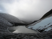
As you walk along the moraine, you get a glimpse of the Mantalai Lake. Climb down the ridge towards the bank of the river where a Lingam of Lord Shiva is placed. From here walk ahead (along the left side of the river bank) till you see a suitable camping spot on a level ground next to the lake. This area is Mantalai considered to be origin of Parvati river.
Night camp in Mantalai Lake
Day 6: Mantalai Lake to Pin-Parvati base camp / Glacier Camp, (15100 feet), 12 km,6 hours
Today is the most difficult day of the trek, the trail can be tiring with a lot of altitude gain. Proceed ahead with a nice level walk along the river. Then you will encounter a tricky section where one is required to cross the ice cold river crossing on bare foot. Look for a shepherd trail taking a sharp turn towards the east. Observe three gulley’s on your way and keep in mind to follow the third gulley. Cross the first gulley and after 30 minutes you will enter into another valley which was unseen until now. The climb can take anything from 4 to 5 hours to complete.
The initial climb will give way to some breathtaking view of the Parvati Valley. You will also see many endangered species of plants and flowers, especially “Losars” and the “Bramhakamals”. The trail crosses an area strewn with huge boulders. Depending on the season the trail from here on can be snow-bound. The weather gets very cold with wind chill factor coming in. After an hour of gradual ascent, the climb now gets steeper and tough. You have reached the lower base camp and still a lot of distance to be covered. After 2 - 3 hours of more climbing, you reach the point from where you see a visible snowline on the ridge. The Pin Parvati Pass is now visible and is in front of you. The older and originally considered Pass can be seen to the right side of the snow ridge. T
Night Stay at the Base Camp
Day 7 & 8 : Parvati Base Camp to Pin Valley’s Dhumdhar Campsite (15,770 feet) via Pin Parvati Pass (17,457 feet), 12 km, 5 - 6 hours
It is advisable to have a rest day for acclimatization and contingency needs. The Base camp tends to get washed out with snow blizzard which blanks the visibility and plummets the temperature to sub zero Celsius. Depending on the weather, start very early in the morning as the pass should not be traversed after Noon due to weather which always detoriates in the second half of the day. Today is a tough day of traversing a crevasse prone ridge.
It takes anything from 2 to 4 hours to reach the top of the pass. Look towards your east (or true right) for the prayer flags which are now visible. After 30 minutes into the hike, locate the first gully and continue with the steep climb.
There is a 984 feet incline through the ice-field which needs to be covered until you reach a higher screeplateau giving a faint impression of a spot where a Advance Base Camp may be set in case of an emergency. This spot is located at an altitude of 16,535 feet. Proceed further with another steep ascent of 660 feet which goes all the way below the pinnacle of the Pass. This may take anything from 45 minutes to 1 hour to traverse. Look for a prominent rock structure in front of you.
Reaching the Pin parvati Pass Finally
Pin Parvati Pass is located at the south of this rock. Another 60 feet steep climb will lead you to the Pin Parvati Pass highest ground. This may take another 30-40 minutes. Care must be taken for the crevasses on this section. At the top of the pass enjoy the view of the lofty snow peaks of Kinnaur, Kullu and Spiti side.
This is where all the steep climbing ends and the descent part begin which can be chellanging for the knee and toes. Way find your way down towards the Spiti side of the valley from the true left of Pin Glacier avoiding heavily crevassed sections.

PinParvatiPass_17000ft
While coming down the steep descent, Look out for the Pin side Base camp visible below also known as Dhumdhar Campsite.
Look for options for crossing the river via snow bridges. If nothing is available ropes and high boots may be required to cross the river. Look out for a meadow spot of land. You have reached Dhumdhar Campsite.
Day 9: Dhumdhar Camp to Mudh via Wickhkhurang Camp (12,600 feet), 20 km approx. 7 – 8 hours
A long day for trekking with beautiful views of Spiti Valley. The day begins with a series of river crossing sections. Make sure they are crossed in the first half of the day when the level of water is manageable. Dhumdhar campsite is at the confluence of the Pin River and a side stream. From the campsite take a 20 minute short climb up the side stream’s glacier section. Then continue 2200 feet (approx.) down on the true left of the valley.
The rest of the nullahs stare one in the face and some have bridges and some have a steel bucket on a pulley. Make these crossing of these side streams till you reach a point where a trail leads to Rampur Bushahr via the Bhabha pass. This section may take 3 to 4 hours to cover.
Another hour of walking leads you to Wichkhurang at 12,600 feet which is a shepherd’s grazing pasture field. The trails are well defined with minimal chances of getting lost. Mudh is another 3 to 4 hours of hike from here and the trail descends to a rock and rubble area till it reaches a big cairn.
The final section is a gradual ascent going along terraced fields to Mudh Village. Stay overnight at Mudh Village and leave for Kaza, through jeep or even take a bus to Kaza.
Further Kaza Site Seeings Awaits You..
How to reach Kullu/Manali
By Air :-
Bhuntar, which is 52 km away from Manali, is the nearest airport. Taxi services are available from Bhuntar to Manali, which costs about Rs. 700- Rs1000. Bhuntar is well connected to Delhi by air. The airliners that take you to this Airport are Indian Airlines, Kingfisher airlines, MDLR Airlines and Jagson Airlines, operating flights from Delhi and Chandigarh to Kullu.
By Road:-
Kullu/Manali is well connected to Delhi. Take an overnight bus from Delhi and you will reach Kullu/Manali in 12 - 14 hours. Tickets can be booked online at www.redbus.in or www.hrtc.gov.in . Tip: Since Delhi Kullu/Manali is a long journey most Volvo private buses leave Delhi between 5 pm and 6 pm. The last govt bus leaves at 8.30 pm from ISBT Kashmere Gate.
Manali to Delhi
Like the onward journey, buses leave from Manali to Delhi between 4 and 5 p.m. Your tentative arrival at Delhi may be anywhere between 6 a.m and 10 a.m. Plan your onward journeys only post noon giving enough buffer for bus delays.
Ref:- India Hikes, Bikat Adventures, Other Trekking Sites, who helped us to present this paper
Pin Parvati Trekking Package - A Trek above 17000 feet - The Highest Mountain pass in Kullu Manali Lahaul Circuit in Himachal - rates-Dates-Costs
Related Tags
pin parvati trek Package Rates Dates Camps|pin parvati pass Trekking Rates Dates Camps|parvati valley trek Rates Dates Camps|pin parvati trek cost|pin parvati trek 2015-2016 Rates Dates Camps|Kheer Ganga Pin Valley Trek Rates Dates Camps|kheerganga trek Rates Dates Camps|sunset at kheer ganga himachal pradesh|kheer ganga height|
- Duration 11 Nights. 12 Days.
- 35600 per person for the group of 4 people.
- 40000 per person for the group of 2 people.
1. Accommodation. (Guest house, Home stay, Camping).
2. Meals while on trek (Veg.).
3. Transport till road head and return. (Kullu to Barsheni and return to Manali).
4. Trek equipment's. Sleeping bag, tent, kitchen tent, toilet tent, mattress, crampon.
5. One night accommodation in Kaza on Day 10 (As per Rates Dates Camps) twin/triple sharing.
6. Qualified & experienced trek Leader, Guide and Support staff.
7. First aid medical kits, stretcher and oxygen cylinder.
8.Entry Permits
Exclusions
1. Any kind of personal expenses.
2. Porter to carry personal luggage.
3. Insurance.
4. Hotel accommodation in Manali.
5. Anything not specifically mentioned under the head.
Note : Trekker must have done at least one Himalayan trek before (14000 Ft.)
Normally TTH expect to carry your personal luggage on your own, if you don't want to carry your backpack so you can give it to porter, but you have to inform us in advance and have to pay Rs. 400/- extra per day per bag.
To book a Trek/ adventure program please use our online booking form or, alternatively, you can call us on the given for confirmation of tour you have to wire a deposit and initial deposit.
Paying the Trek/ Adventure activity fee:
The fee can be paid by online transfer/check deposit/ demand draft. Instruction for payment will be forwarded along with your confirmation email.
When your transfer is done, please e-mail us a confirmation mail with your transfer details, so that we can follow up your reservation efficiently.
When to book:
It is wise to make your booking at least two months in advance. However, if you want a good deal on your domestic/international flight, we recommend organising your trip at least five months in advance. (Please contact us if you require a late booking)
In the event of cancellation of trek/adventure activity services due to any avoidable / unavoidable reasons we must be notified of the same in writing. Cancellation charges will be effective from the date we receive advice in writing, and cancellation charges would be as follows: -
Pin Parvati Trekking Package - A Trek above 17000 feet - Trekking in The Highest Mountain pass in Kullu Manali Lahaul Circuit in Himachal
Related Tags
pin parvati trek Package Inclusions|pin parvati pass Trekking inclusions|parvati valley trek Inclusions|pin parvati trek cost|pin parvati trek 2015-2016 Inclusions|Kheer Ganga Pin Valley Trek Inclusions|kheerganga trek Inclusions|sunset at kheer ganga himachal pradesh|kheer ganga height|
- Duration 11 Nights. 12 Days.
- 35600 per person for the group of 4 people.
- 40000 per person for the group of 2 people.
1. Accommodation. (Guest house, Home stay, Camping).
2. Meals while on trek (Veg.).
3. Transport till road head and return. (Kullu to Barsheni and return to Manali).
4. Trek equipment's. Sleeping bag, tent, kitchen tent, toilet tent, mattress, crampon.
5. One night accommodation in Kaza on Day 10 (As per itinerary) twin/triple sharing.
6. Qualified & experienced trek Leader, Guide and Support staff.
7. First aid medical kits, stretcher and oxygen cylinder.
8.Entry Permits
Exclusions
1. Any kind of personal expenses.
2. Porter to carry personal luggage.
3. Insurance.
4. Hotel accommodation in Manali.
5. Anything not specifically mentioned under the head.
Note : Trekker must have done at least one Himalayan trek before (14000 Ft.)
Normally TTH expect to carry your personal luggage on your own, if you don't want to carry your backpack so you can give it to porter, but you have to inform us in advance and have to pay Rs. 400/- extra per day per bag.
To book a Trek/ adventure program please use our online booking form or, alternatively, you can call us on the given for confirmation of tour you have to wire a deposit and initial deposit.
Paying the Trek/ Adventure activity fee:
The fee can be paid by online transfer/check deposit/ demand draft. Instruction for payment will be forwarded along with your confirmation email.
When your transfer is done, please e-mail us a confirmation mail with your transfer details, so that we can follow up your reservation efficiently.
When to book:
It is wise to make your booking at least two months in advance. However, if you want a good deal on your domestic/international flight, we recommend organising your trip at least five months in advance. (Please contact us if you require a late booking)
In the event of cancellation of trek/adventure activity services due to any avoidable / unavoidable reasons we must be notified of the same in writing. Cancellation charges will be effective from the date we receive advice in writing, and cancellation charges would be as follows: -
Pin Parvati Trekking Package - A Trek above 17000 feet - The Highest Mountain pass in Kullu Manali Lahaul Circuit in Himachal - Itinarary
Related Tags
pin parvati trek Package Itinerary|pin parvati pass Trekking Itinerary|parvati valley trek Itinerary|pin parvati trek cost|pin parvati trek 2015-2016 Itinerary|Kheer Ganga Pin Valley Trek Itinerary|kheerganga trek Itinerary|sunset at kheer ganga himachal pradesh|kheer ganga height|
Highest altitude:- 5319 Meters.
Grade:- Strenuous
Best Season:- July to September
Day 01:- Manali - to Barsheni - 6 Hour Drive. Trek to Kalga camp - 4 hours. Leaving Manali early, we reach Manikaran with its Sikh Temple and hot springs early afternoon. Porters await us to take us for the short trek to our forest camp at Phulga. This is about 4 hours We go along the right bank of the Parvati River through a broad forest road. Camp near the forest Rest House for the night.
Day 02:- Kalga - Khirganga 2960m - 4-5 Hours The trek again is through forests and the surrounding mountains make a beautiful backdrop. We reach Khirganga known for its hot springs and its solitary temple on a rock. Camp overnight.
Day 03:- Khirganga - Tunda Bhuj 3285m. 4-5 hours. We cross meadows and forests and as the valley opens up we reach our campsite at Tunda Bhuj. The surrounding thickly wooded hills present a soothing sight as we relax at our camp.
Day 04:- Tunda Bhuj - Pandu Bridge - 3700. 7 hours. Today is a long day as we go through thinning forests of Birch and conifer and head out above the tree line. Bushes and scrub appear and the trail becomes a bit rough with stones and boulders. We cross two meadows and reach the natural rock bridges at Pandu Pul. Crossing this natural bridge, we head on to our campsite.
Day 05:- Pandu Bridge to Mantalai - 8-9 Hours The trail climbs steadily towards the glacial lake of Mantalai which is also considered the source of the Parvati River.
Day 06:- Mantalai to Base of Pass - 4150 m. 5-6Hours There are numerous stream emerging from this small lake. The path now consists of mainly moraine as we head towards our campsite at an altitude of about 4400m.
Day 07:- Base of Pass to the other side - 4000m. 10 -11 hours. The trail is covered with snow almost year round. The path is only known to trekkers who have been there before and our expert guide leads you through a small snowfield to the top of the pass at 5319m. Boulders emerge from the snow as we cross the pass and descend to the other side. Camp is held at 4000m.
Day 08:- From Camp to Thanpathan We are now technically in the Pin Valley and skirting the Great Himalayan National Park we head down to the valley floor.camp overnight.
Day 09:- From Thannpathan to Mud Village We encounter the pin river, rushing towards meeting the spiti river, and wide valley Camp overnight near village of Mud.
Day 10:- Mud - Sagnam - 5 Hours. There is a road which now leads to the next village of Sagnam. Rest day.visit Kungri Gompa, return to Camp.
Day 11:- Drive to Kaza - 25 Kms From here, we board a jeep to take us to Kaza 25 Km away. Check into a Guest House for the night.
Day 12:- Delhi Departure